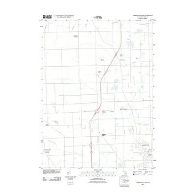
2011 Map of Lambertville West
USGS Topo · Published 2011About this map
Lambertville serves as a primary population center in this part of Monroe County, characterized by a grid of residential streets and localized services including the Lambertville Post Office. The landscape is defined by an extensive network of drainage ditches such as North Tenmile Creek, Halfway Creek, and the Summerfield and Ida Drain, which manage the low-lying terrain near the Ottawa Lakebed. These hydrological features illustrate the region's transition from wetlands to agricultural and residential use.
Find a feature on this map
25 named features on this map. Tap any name to fly to it.
Don’t see what you’re looking for? This feature index may not catch every label — zoom into the map to look around manually.
Map Details
Editions of this 2011 Lambertville West Map
This is the sole edition of this map. No revisions or reprints were ever made.
Other maps of this area

1900 · Toledo
USGS Topo · 1:62,500

1911 · Swanton
USGS Topo · 1:62,500

1912 · Dundee
USGS Topo · 1:62,500

1914 · Swanton
USGS Topo · 1:62,500

1926 · Dundee
USGS Topo · 1:62,500

1935 · Berkey
USGS Topo · 1:24,000

1936 · Samaria
USGS Topo · 1:31,680
1936 · Ida
USGS Topo · 1:31,680
1937 · Sylvania
USGS Topo · 1:31,680
1938 · Toledo
USGS Topo · 1:31,680
Featured Places
- Bedford Township, MI
- Lambertville, Bedford Township
- Ida Township, MI
- Whiteford Township, MI
- Summerfield Township, MI