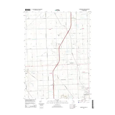
2014 Map of Lambertville West
USGS Topo · Published 2014About this map
Lambertville and the surrounding agricultural landscape of Monroe County are defined by an intricate network of drainage ditches and creeks. This 2014 survey illustrates how the low-lying terrain, including the expansive Ottawa Lakebed, has been modified over decades to support farming and settlement. Key water features such as Ottawa Lake Outlet, Halfway Creek, and Sink Creek segment the grid of rural roads like Ida Center Rd and Sylvania Petersburg Rd. The map documents established communities at Saint Anthony and Whiteford Center, along with local landmarks including Ham-A-Lot Field Airport and Air Rahe Airport. Genealogists will find the locations of Zion Cem and Lambertville Cem useful for tracing family ties within these townships.
Find a feature on this map
87 named features on this map. Tap any name to fly to it.
Don’t see what you’re looking for? This feature index may not catch every label — zoom into the map to look around manually.
Map Details
Editions of this 2014 Lambertville West Map
This is the sole edition of this map. No revisions or reprints were ever made.
Other maps of this area

1900 · Toledo
USGS Topo · 1:62,500

1911 · Swanton
USGS Topo · 1:62,500

1912 · Dundee
USGS Topo · 1:62,500

1914 · Swanton
USGS Topo · 1:62,500

1926 · Dundee
USGS Topo · 1:62,500

1935 · Berkey
USGS Topo · 1:24,000

1936 · Samaria
USGS Topo · 1:31,680
1936 · Ida
USGS Topo · 1:31,680
1937 · Sylvania
USGS Topo · 1:31,680
1938 · Toledo
USGS Topo · 1:31,680
Featured Places
- Bedford Township, MI
- Lambertville, Bedford Township
- Ida Township, MI
- Whiteford Township, MI
- Summerfield Township, MI