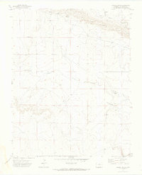
1971 Map of Lambing Spring
USGS Topo · Published 1974About this map
Lambing Spring and the distinctive geological formation known as The Hogback define this high-plains landscape in southern Colorado. Surveyed in the late 1960s, the terrain is shaped by intermittent watercourses like Luning Arroyo and Bremer Arroyo, which cut through the arid ranching country of Las Animas County. The presence of a Gaging Sta along the drainage suggests a focus on water resource management in this dry environment. Human activity is largely industrial and utilitarian, marked by scattered Gravel Pits and several water storage Tanks. The map reveals a sparsely settled region where survival and industry are dictated by the underlying topography and the rare reliable water sources like the primary spring and various unnamed Spring seeps located throughout the township divisions.
Find a feature on this map
12 named features on this map. Tap any name to fly to it.
Don’t see what you’re looking for? This feature index may not catch every label — zoom into the map to look around manually.
Map Details
Editions of this 1971 Lambing Spring Map
2 editions found
Other maps of this area

1891 · Mesa De Maya
USGS Topo · 1:125,000

1892 · Elmoro
USGS Topo · 1:125,000

1893 · Elmoro
USGS Topo · 1:125,000

1893 · Mesa de Maya
USGS Topo · 1:125,000

1897 · Elmoro
USGS Topo · 1:125,000

1954 · Trinidad
USGS Topo · 1:250,000

1955 · La Junta
USGS Topo · 1:250,000

1955 · Trinidad
USGS Topo · 1:250,000

1958 · La Junta
USGS Topo · 1:250,000

1958 · Trinidad
USGS Topo · 1:250,000