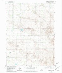
1982 Map of Lambs Lake NE
USGS Topo · Published 1982About this map
The rolling sandhill terrain of northern Holt County is defined here by its scattered water sources and isolated rural schoolhouses. Agricultural life in the early 1980s relied heavily on subterranean access, evidenced by numerous groundwater points such as Flowing Well and several generic Wells markers. The landscape is sparse, with Holt Creek providing a primary drainage feature in the southern portion of the quadrangle. This map serves as an important record for genealogical research, pinpointing the locations of four specific district schools, including School No 169, School No 313, School No 77, and School No 210. These numbered schools represent the decentralized educational system that once served the remote ranching families of this Nebraska region, long before further school consolidation altered the local social geography.
Find a feature on this map
12 named features on this map. Tap any name to fly to it.
Don’t see what you’re looking for? This feature index may not catch every label — zoom into the map to look around manually.
Map Details
Editions of this 1982 Lambs Lake NE Map
This is the sole edition of this map. No revisions or reprints were ever made.
Other maps of this area

1954 · McCook
USGS Topo · 1:250,000

1957 · McCook
USGS Topo · 1:250,000

1958 · McCook
USGS Topo · 1:250,000

1973 · Imperial NE
USGS Topo · 1:24,000

1973 · Imperial
USGS Topo · 1:24,000

1973 · Dittons Creek NW
USGS Topo · 1:24,000
1973 · Grant
USGS Topo · 1:24,000
1973 · Imperial NW
USGS Topo · 1:24,000
1973 · Elsie
USGS Topo · 1:24,000

1973 · Imperial Municipal Airport
USGS Topo · 1:24,000