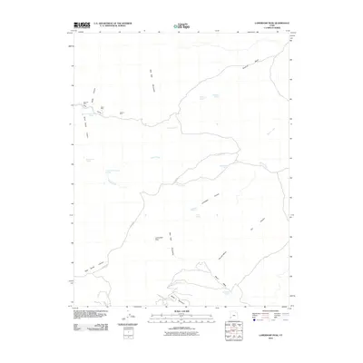
2010 Map of Lamerdorf Peak
USGS Topo · Published 2010About this map
Wah Wah Mountains dominate the landscape of this 2010 survey, providing a detailed look at the mineral and water resources of this part of Beaver County. Mining history is evident across the terrain, with specific sites such as Revenue Mine, the Tasso Mine, and The Lou Mine situated in the northern reaches near Revenue Basin. To the south, The Iron Mines sit nestled between the slopes of Lamerdorf Peak and the drainage of Blawn Wash.
Find a feature on this map
28 named features on this map. Tap any name to fly to it.
Don’t see what you’re looking for? This feature index may not catch every label — zoom into the map to look around manually.
Map Details
Editions of this 2010 Lamerdorf Peak Map
This is the sole edition of this map. No revisions or reprints were ever made.
Other maps of this area

1953 · Richfield
USGS Topo · 1:250,000

1958 · Richfield
USGS Topo · 1:250,000

1959 · Frisco
USGS Topo · 1:62,500

1971 · Observation Knoll
USGS Topo · 1:24,000

1971 · Pine Grove Reservoir
USGS Topo · 1:24,000

1971 · Sewing Machine Pass
USGS Topo · 1:24,000

1971 · Lamerdorf Peak NW
USGS Topo · 1:24,000
1971 · Blue Mountain
USGS Topo · 1:24,000
1971 · The Tetons
USGS Topo · 1:24,000

1971 · Lamerdorf Peak
USGS Topo · 1:24,000