
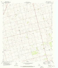
1970 Map of Lamesa South
USGS Topo · Published 1973About this map
Lamesa occupies the northern reaches of this West Texas survey, a High Plains community shaped by its position along the Atchison Topeka and Santa Fe railroad. The town's layout reflects a classic mid-century educational and civic structure, featuring several neighborhood schools like V Z Rogers Sch and the central High Sch. To the southwest, the Lamesa West Oil Field indicates the region's industrial backbone, where pumping stations and storage tanks dot the landscape alongside the natural geography of Sulphur Springs Draw. Away from the urban grid, the map records the recreational and utility-based edges of town, including the Lamesa Municipal Airfield, the Rodeo Ground, and the local Memorial Park (Cem). The terrain beyond the town limits is defined by intermittent water features like Fivemile and scattered Gravel Pits, illustrating a landscape driven by resource extraction and cattle ranching.
Find a feature on this map
24 named features on this map. Tap any name to fly to it.
Don’t see what you’re looking for? This feature index may not catch every label — zoom into the map to look around manually.
Map Details
Editions of this 1970 Lamesa South Map
This is the sole edition of this map. No revisions or reprints were ever made.
Other maps of this area

1954 · Hobbs
USGS Topo · 1:250,000

1954 · Big Spring
USGS Topo · 1:250,000

1958 · Big Spring
USGS Topo · 1:250,000

1958 · Hobbs
USGS Topo · 1:250,000

1968 · Lamesa North
USGS Topo · 1:24,000

1968 · Hancock
USGS Topo · 1:24,000

1969 · Punkin Center
USGS Topo · 1:24,000

1970 · Patricia
USGS Topo · 1:24,000

1970 · Key
USGS Topo · 1:24,000
1970 · Tenmile
USGS Topo · 1:24,000