
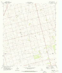
1970 Map of Patricia
USGS Topo · Published 1973About this map
The Breedlove Oil Field dominates the southern landscape of this West Texas region, illustrating the region's industrial focus during the early 1970s. Spanning the Dawson Co Martin Co line, the map details a land defined by extraction and resource management, where numerous Oil Wells and a Drill Hole are scattered across the terrain. The small community of Patricia serves as the primary settlement hub, situated at a junction of secondary highways that navigate the flat, high plains topography.
Find a feature on this map
11 named features on this map. Tap any name to fly to it.
Don’t see what you’re looking for? This feature index may not catch every label — zoom into the map to look around manually.
Map Details
Editions of this 1970 Patricia Map
This is the sole edition of this map. No revisions or reprints were ever made.
Other maps of this area

1954 · Hobbs
USGS Topo · 1:250,000

1954 · Big Spring
USGS Topo · 1:250,000

1958 · Big Spring
USGS Topo · 1:250,000

1958 · Hobbs
USGS Topo · 1:250,000

1966 · Wolcott Ranch
USGS Topo · 1:24,000

1966 · Flower Grove
USGS Topo · 1:24,000

1966 · Scharbauer Ranch
USGS Topo · 1:24,000

1970 · Patricia SW
USGS Topo · 1:24,000

1970 · Lamesa South
USGS Topo · 1:24,000
1970 · Tenmile
USGS Topo · 1:24,000