
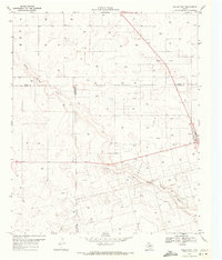
1969 Map of Punkin Center
USGS Topo · Published 1971About this map
Punkin Center and Mungerville anchor this West Texas landscape in the late 1960s, a period defined by the extensive development of the Permian Basin's water and mineral resources. The terrain is characterized by the winding path of Sulphur Springs Draw, which cuts a distinct topographic profile across the plains. Human activity is heavily focused on subsurface extraction, evidenced by a dense network of wells and oil wells that dot nearly every section of the grid. For genealogists and local historians, the inclusion of Fairview Cem and the Radio Tower near the heart of the settlement provides specific geographic markers for family sites and community landmarks during this era of agricultural and industrial stability.
Find a feature on this map
8 named features on this map. Tap any name to fly to it.
Don’t see what you’re looking for? This feature index may not catch every label — zoom into the map to look around manually.
Map Details
Editions of this 1969 Punkin Center Map
This is the sole edition of this map. No revisions or reprints were ever made.
Other maps of this area

1954 · Hobbs
USGS Topo · 1:250,000

1954 · Big Spring
USGS Topo · 1:250,000

1958 · Big Spring
USGS Topo · 1:250,000

1958 · Hobbs
USGS Topo · 1:250,000

1968 · Lamesa North
USGS Topo · 1:24,000

1969 · Welch East
USGS Topo · 1:24,000

1969 · Gooch Lake
USGS Topo · 1:24,000

1969 · Welch SW
USGS Topo · 1:24,000
1969 · Welch West
USGS Topo · 1:24,000

1970 · Lamesa South
USGS Topo · 1:24,000