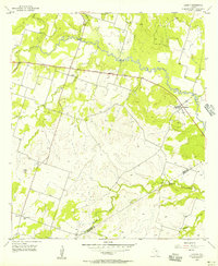
1956 Map of Lamkin
USGS Topo · Published 1957About this map
Leon River meanders across the northern portion of this Texas mid-century landscape, framing a rural territory where the borders of Comanche and Hamilton counties meet. The small settlement of Lamkin serves as a local focal point, anchored by the Community Tabernacle and a Community Building, while the hamlet of Energy sits to the southwest near the Energy Cemetery. These tiny nodes of habitation are connected by the 36th Division Memorial Highway, which cuts a straight path through the rolling terrain.
Find a feature on this map
18 named features on this map. Tap any name to fly to it.
Don’t see what you’re looking for? This feature index may not catch every label — zoom into the map to look around manually.
Map Details
Editions of this 1956 Lamkin Map
2 editions found
Other maps of this area

1888 · Hamilton
USGS Topo · 1:125,000

1894 · Hamilton
USGS Topo · 1:125,000

1954 · Brownwood
USGS Topo · 1:250,000

1956 · Gustine
USGS Topo · 1:62,500

1956 · Gentrys Mill
USGS Topo · 1:24,000

1956 · Gustine
USGS Topo · 1:24,000

1956 · Pottsville
USGS Topo · 1:62,500

1956 · Hico
USGS Topo · 1:62,500

1956 · Hamilton
USGS Topo · 1:62,500

1956 · Hamilton West
USGS Topo · 1:24,000