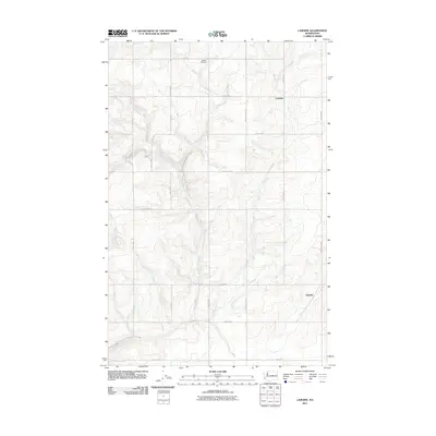
2011 Map of Lamoine
USGS Topo · Published 2011About this map
Douglas Creek cuts a deep, winding path through the plateau of Douglas County, defining the drainage pattern of this agricultural landscape. The settlement of Lamoine sits atop the high ground to the northeast, while Supplee is situated further south along the eastern edge of the quadrangle. This 2011 survey reveals a persistent grid of section-line roads, many bearing family names that reflect the area's homesteading heritage, such as Marshall Rd NW, Slusser Rd NW, and Brandts Rd NW. Genealogy researchers will find the Fletcher Cemetery on the northern plains, a quiet landmark in an area dominated by dryland farming and the deep coulees of the Columbia River basin. The map illustrates how modern infrastructure, like Road 1 NW and Road 8 NW, continues to follow the rigid township-and-range lines established over a century earlier.
Find a feature on this map
26 named features on this map. Tap any name to fly to it.
Don’t see what you’re looking for? This feature index may not catch every label — zoom into the map to look around manually.
Map Details
Editions of this 2011 Lamoine Map
This is the sole edition of this map. No revisions or reprints were ever made.
Other maps of this area

1901 · Chelan
USGS Topo · 1:125,000

1953 · Ritzville
USGS Topo · 1:250,000

1957 · Wenatchee
USGS Topo · 1:250,000

1959 · Ritzville
USGS Topo · 1:250,000

1965 · Ritzville
USGS Topo · 1:250,000

1968 · Withrow
USGS Topo · 1:24,000

1968 · Chelan
USGS Topo · 1:24,000

1968 · Lamoine
USGS Topo · 1:24,000

1968 · Chelan Falls
USGS Topo · 1:24,000
1968 · Alstown
USGS Topo · 1:24,000