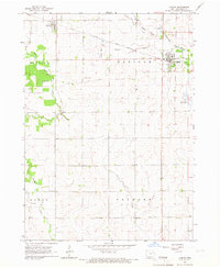
1965 Map of Lamont
USGS Topo · Published 1967About this map
Lamont and Aurora anchor this mid-1960s survey of eastern Buchanan County, where the agricultural landscape is defined by the Chicago Great Western railroad line. The tracks cut across the northern reaches of the map, passing through both primary settlements and providing a vital link for the regional economy. The drainage patterns of the South Fork Maquoketa River and Buffalo Creek reveal a terrain shaped by water, with various quarries and gravel pits scattered near the riverbanks. For those tracing family histories in the townships of Madison, Buffalo, Byron, and Fremont, several rural burial grounds are documented, including Madison Cem and Byron Cem. A small Landing Field south of Lamont adds a modern transportation element to an otherwise traditional farming and rail corridor.
Find a feature on this map
19 named features on this map. Tap any name to fly to it.
Don’t see what you’re looking for? This feature index may not catch every label — zoom into the map to look around manually.
Map Details
Editions of this 1965 Lamont Map
2 editions found
Other maps of this area

1901 · Oelwein
USGS Topo · 1:125,000

1903 · Winthrop
USGS Topo · 1:125,000

1959 · Dubuque
USGS Topo · 1:250,000

1961 · Dubuque
USGS Topo · 1:250,000

1962 · Dubuque
USGS Topo · 1:250,000

1965 · Strawberry Point
USGS Topo · 1:24,000

1965 · Arlington
USGS Topo · 1:24,000

1965 · Lamont
USGS Topo · 1:24,000

1965 · Dundee
USGS Topo · 1:24,000
1973 · Quasqueton
USGS Topo · 1:24,000