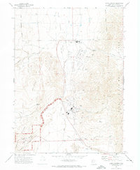
1972 Map of Lampo Junction
USGS Topo · Published 1973About this map
Blue Creek Valley serves as a central corridor for industry and transportation in this northern Utah landscape. The map highlights the Chemical Plant and its associated infrastructure, including a Substation and Radio Facility, situated just north of Lampo Junction. This area reflects the Cold War era's industrial footprint, where the valley floor accommodated both a Landing Strip and multiple Gravel Pits.
Find a feature on this map
29 named features on this map. Tap any name to fly to it.
Don’t see what you’re looking for? This feature index may not catch every label — zoom into the map to look around manually.
Map Details
Editions of this 1972 Lampo Junction Map
This is the sole edition of this map. No revisions or reprints were ever made.
Other maps of this area

1954 · Public Shooting Grounds
USGS Topo · 1:24,000

1954 · Brigham City
USGS Topo · 1:250,000

1958 · Brigham City
USGS Topo · 1:250,000

1961 · Thatcher Mountain
USGS Topo · 1:62,500

1962 · Brigham City
USGS Topo · 1:250,000

1966 · Thatcher Mountain SW
USGS Topo · 1:24,000

1967 · Golden Spike Monument
USGS Topo · 1:24,000

1968 · Sunset Pass
USGS Topo · 1:24,000

1968 · Howell
USGS Topo · 1:24,000
1968 · Blind Springs
USGS Topo · 1:24,000