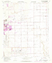
1958 Map of Lancaster East
USGS Topo · Published 1975About this map
Lancaster anchors the western edge of this mid-century survey, showing the transition from an established town center to the sprawling desert infrastructure of the Antelope Valley. The southern portion is dominated by the massive industrial footprint of Air Force Plant 42, a facility central to the region’s Cold War aerospace legacy. The grid system of the valley is clearly defined by lettered thoroughfares like Ave J and Lancaster Blvd, which connect the growing urban core to outlying settlements such as Roosevelt and Desert Haven.
Find a feature on this map
27 named features on this map. Tap any name to fly to it.
Don’t see what you’re looking for? This feature index may not catch every label — zoom into the map to look around manually.
Map Details
Editions of this 1958 Lancaster East Map
3 editions found
Other maps of this area

1915 · Elizabeth Lake
USGS Topo · 1:125,000

1917 · Elizabeth Lake
USGS Topo · 1:125,000

1930 · Oban
USGS Topo · 1:24,000

1930 · Roosevelt School
USGS Topo · 1:24,000

1930 · Casa Desierta
USGS Topo · 1:24,000

1930 · Lancaster
USGS Topo · 1:24,000

1930 · West Alpine Butte
USGS Topo · 1:24,000

1930 · Tierra Bonita
USGS Topo · 1:24,000

1933 · Lancaster
USGS Topo · 1:24,000

1933 · Casa Desierta
USGS Topo · 1:24,000