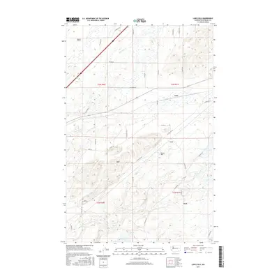
2017 Map of Lance Hills
USGS Topo · Published 2017About this map
Lance Hill Cem and the surrounding high ground of the Lance Hills define this corner of Spokane County. The landscape is characterized by a series of small, scattered water bodies including Campbell Lake, Ballinger Lake, and Alkali Lake, which punctuate the terrain between the elevations of Bunker Hill and the drainage of Hog Canyon Cr. This era shows a network of named rural roads like W Lance Hill Rd and S Ritchey Rd connecting isolated settlements such as Babb, Geib, and Mock. The northern section is dominated by the open expanse of Malloy Prairie, while the southern portion features more complex hydrology with Little Mason Lake, Bunn Lake, and Martin Lake. The map provides a clear record of land divisions and rural property access during the late 2010s, reflecting the enduring agricultural and pastoral character of this region.
Find a feature on this map
45 named features on this map. Tap any name to fly to it.
Don’t see what you’re looking for? This feature index may not catch every label — zoom into the map to look around manually.
Map Details
Editions of this 2017 Lance Hills Map
This is the sole edition of this map. No revisions or reprints were ever made.
Other maps of this area

1943 · Medical Lake
USGS Topo · 1:62,500

1945 · Reardan
USGS Topo · 1:62,500

1953 · Reardan
USGS Topo · 1:62,500

1954 · Medical Lake
USGS Topo · 1:24,000

1954 · Medical Lake
USGS Topo · 1:62,500

1954 · Cheney
USGS Topo · 1:62,500
1954 · Four Lakes
USGS Topo · 1:24,000

1954 · Sprague
USGS Topo · 1:62,500

1955 · Spokane
USGS Topo · 1:250,000

1958 · Spokane
USGS Topo · 1:250,000