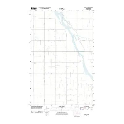
2011 Map of Landa SW
USGS Topo · Published 2011About this map
The Souris River meanders across this rural landscape in Bottineau County, defining the local geography as it flows through the north-central North Dakota plains. This 2011 survey captures the area’s distinct section-line grid, where a network of rural routes like 100th St NW and 13th Ave NW frame a landscape of agricultural fields and prairie potholes. The river itself creates a corridor of riparian terrain, accompanied by the Refuge Private Rd and drainage from Boundary Creek near the eastern edge. While the map is dominated by these natural water features and vast open spaces, the detailed infrastructure of rural living is visible in the placement of access roads such as Grassland Trl and County Rd 27b, which connect the remote farmsteads and field access points that sustain the local economy.
Find a feature on this map
19 named features on this map. Tap any name to fly to it.
Don’t see what you’re looking for? This feature index may not catch every label — zoom into the map to look around manually.
Map Details
Editions of this 2011 Landa SW Map
This is the sole edition of this map. No revisions or reprints were ever made.
Other maps of this area

1949 · Eckman
USGS Topo · 1:24,000

1949 · Landa
USGS Topo · 1:24,000

1949 · Landa SW
USGS Topo · 1:24,000

1950 · Newburg
USGS Topo · 1:24,000

1950 · Deep
USGS Topo · 1:24,000

1950 · Landa
USGS Topo · 1:24,000

1950 · Landa SW
USGS Topo · 1:24,000

1951 · Westhope SE
USGS Topo · 1:24,000
1951 · Westhope
USGS Topo · 1:24,000

1954 · Landa SE
USGS Topo · 1:24,000