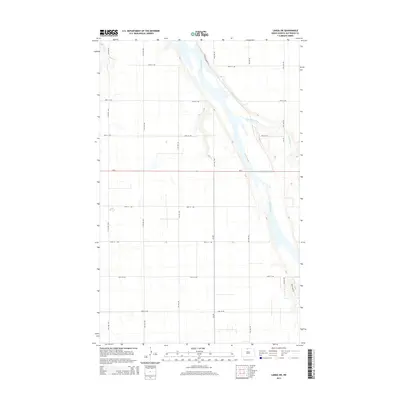
2014 Map of Landa SW
USGS Topo · Published 2014About this map
Souris River meanders through this portion of Bottineau County, defining the drainage patterns of the northern Great Plains. In this 2014 survey, the river is joined by Boundary Creek as it flows through a landscape dominated by a rigid section-line road grid. The map reveals the intersection of agricultural utility and conservation efforts, noted by the presence of Refuge Private Rd and the Grassland Trl near the river's edge. State highway Nd-5 provides the primary east-west corridor, cutting through the center of the quadrangle and connecting the various numbered avenues and streets that partition the rural terrain. This topographical study captures the characteristic North Dakota prairie where natural waterways and human engineering meet in a precisely surveyed environment.
Find a feature on this map
21 named features on this map. Tap any name to fly to it.
Don’t see what you’re looking for? This feature index may not catch every label — zoom into the map to look around manually.
Map Details
Editions of this 2014 Landa SW Map
This is the sole edition of this map. No revisions or reprints were ever made.
Other maps of this area

1949 · Eckman
USGS Topo · 1:24,000

1949 · Landa
USGS Topo · 1:24,000

1949 · Landa SW
USGS Topo · 1:24,000

1950 · Newburg
USGS Topo · 1:24,000

1950 · Deep
USGS Topo · 1:24,000

1950 · Landa
USGS Topo · 1:24,000

1950 · Landa SW
USGS Topo · 1:24,000

1951 · Westhope SE
USGS Topo · 1:24,000
1951 · Westhope
USGS Topo · 1:24,000

1954 · Landa SE
USGS Topo · 1:24,000