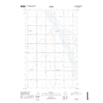
2020 Map of Landa SW
USGS Topo · Published 2020About this map
The Souris River meanders through the eastern portion of this Bottineau County landscape, creating a wide riparian corridor of wetlands and oxbows within the northern plains. This 2020 survey illustrates the characteristic section-line road network of North Dakota, where routes like 100th St NW and Co Rd 27B provide access to the vast agricultural plots. The confluence of Boundary Creek with the larger river system highlights the essential drainage patterns of this prairie region. Located near the international border, the area is defined by its rectilinear grid and the life-giving presence of the river, which breaks the geometric regularity of the surveyed townships. Genealogists and local historians can use the precise grid coordinates, such as 13th Ave NW, to locate specific family farmsteads and historic land patents across the T162N and T161N townships.
Find a feature on this map
22 named features on this map. Tap any name to fly to it.
Don’t see what you’re looking for? This feature index may not catch every label — zoom into the map to look around manually.
Map Details
Editions of this 2020 Landa SW Map
This is the sole edition of this map. No revisions or reprints were ever made.
Other maps of this area

1949 · Eckman
USGS Topo · 1:24,000

1949 · Landa
USGS Topo · 1:24,000

1949 · Landa SW
USGS Topo · 1:24,000

1950 · Newburg
USGS Topo · 1:24,000

1950 · Deep
USGS Topo · 1:24,000

1950 · Landa
USGS Topo · 1:24,000

1950 · Landa SW
USGS Topo · 1:24,000

1951 · Westhope SE
USGS Topo · 1:24,000
1951 · Westhope
USGS Topo · 1:24,000

1954 · Landa SE
USGS Topo · 1:24,000