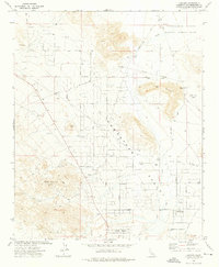
1972 Map of Landers
USGS Topo · Published 1976About this map
Homestead Valley defines the high desert landscape of this 1972 survey, centered on the emerging community of Landers and the southern edge of the Twentynine Palms Marine Corps Base. The map reveals a transition from the mid-century aviation era to residential growth, marked by the presence of two airstrips: Giant Rock Airport and Landers Airport. The desert floor is intricately networked with named roads and tracks, such as Milne Road and Happy Trail, serving scattered outposts like Reche Wells and Flamingo Heights. The terrain is anchored by the distinct profiles of Spy Mountain and Ruby Mountain, while the hydrology is dominated by the ephemeral Pipes Wash. This record captures the region shortly after the initial homesteading boom, showing the grid of desert blocks and mining remnants like the New Dixie Mine Rd.
Find a feature on this map
40 named features on this map. Tap any name to fly to it.
Don’t see what you’re looking for? This feature index may not catch every label — zoom into the map to look around manually.
Map Details
Editions of this 1972 Landers Map
2 editions found
Other maps of this area

1901 · Southern California Sheet No. 1
USGS Topo · 1:250,000

1902 · San Gorgonio
USGS Topo · 1:125,000

1904 · Southern California Sheet No. 1
USGS Topo · 1:250,000

1953 · San Bernardino
USGS Topo · 1:250,000

1954 · Hidalgo Mtn
USGS Topo · 1:24,000

1954 · Emerson Lake
USGS Topo · 1:24,000

1955 · Goat Mountain
USGS Topo · 1:24,000

1955 · Old Woman Springs
USGS Topo · 1:62,500

1955 · Emerson Lake
USGS Topo · 1:62,500

1955 · Morongo Valley
USGS Topo · 1:62,500