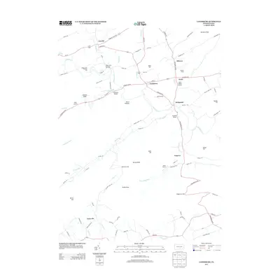
2013 Map of Landisburg
USGS Topo · Published 2013About this map
Landisburg and its surrounding agricultural valleys are the focal point of this 2013 survey, which illustrates the intersection of small Pennsylvania settlements and the undulating terrain of the Blue Ridge. The course of Shermans Cr winds through the center of the quadrangle, passing the village of Bridgeport and the landing strip at Egolf Airport. To the north, the landscape is defined by the settlements of Loysville and Milltown, while the southern reaches are marked by the steep ascent toward Waggoners Gap and the prominence of Mount Dempsey. Local history researchers will find a detailed network of family-named roads and landmarks, such as Bells Hill and Sheaffer Valley, alongside community institutions like the Hidden Valley Boy Scout Camp. The map provides a clear picture of the modern rural infrastructure, including secondary airports and the local road networks that have long connected these valley townships.
Find a feature on this map
96 named features on this map. Tap any name to fly to it.
Don’t see what you’re looking for? This feature index may not catch every label — zoom into the map to look around manually.
Map Details
Editions of this 2013 Landisburg Map
This is the sole edition of this map. No revisions or reprints were ever made.
Other maps of this area

1904 · Carlisle
USGS Topo · 1:62,500

1907 · New Bloomfield
USGS Topo · 1:62,500

1919 · Newville
USGS Topo · 1:62,500

1930 · Loysville
USGS Topo · 1:62,500

1933 · Loysville
USGS Topo · 1:62,500

1943 · New Bloomfield
USGS Topo · 1:62,500

1943 · Carlisle
USGS Topo · 1:62,500

1945 · Newville
USGS Topo · 1:62,500

1950 · Harrisburg
USGS Topo · 1:250,000
1952 · Spruce Hill
USGS Topo · 1:24,000
Featured Places
- Saville Township, PA
- Landisburg, PA
- Tyrone Township, PA
- Northeast Madison Township, PA
- Southwest Madison Township, PA