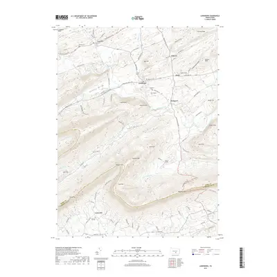
2019 Map of Landisburg
USGS Topo · Published 2019About this map
Shermans Creek winds through the heart of this Perry County landscape, connecting the long-established settlements of Landisburg and Bridgeport. The terrain is defined by a series of parallel ridges and valleys characteristic of the Appalachian range, including Sheaffer Valley and Kennedy Valley. Significant local infrastructure is visible in the form of Egolf Airport and Shulls Airport, while genealogy interests are served by the location of Restland Cem near Loysville and Mcclures Gap Cem to the south. The map documents a rural corridor where historic roads like Shermans Valley Rd and Waggoners Gap Rd follow the natural contours of the land, providing a clear picture of the region's 21st-century development pattern. To the south, the crossing at Waggoners Gap marks the transition across the border between Perry Co and Cumberland Co.
Find a feature on this map
94 named features on this map. Tap any name to fly to it.
Don’t see what you’re looking for? This feature index may not catch every label — zoom into the map to look around manually.
Map Details
Editions of this 2019 Landisburg Map
This is the sole edition of this map. No revisions or reprints were ever made.
Other maps of this area

1904 · Carlisle
USGS Topo · 1:62,500

1907 · New Bloomfield
USGS Topo · 1:62,500

1919 · Newville
USGS Topo · 1:62,500

1930 · Loysville
USGS Topo · 1:62,500

1933 · Loysville
USGS Topo · 1:62,500

1943 · New Bloomfield
USGS Topo · 1:62,500

1943 · Carlisle
USGS Topo · 1:62,500

1945 · Newville
USGS Topo · 1:62,500

1950 · Harrisburg
USGS Topo · 1:250,000
1952 · Spruce Hill
USGS Topo · 1:24,000
Featured Places
- Saville Township, PA
- Landisburg, PA
- Tyrone Township, PA
- Northeast Madison Township, PA
- Southwest Madison Township, PA