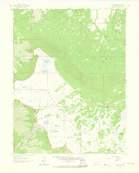
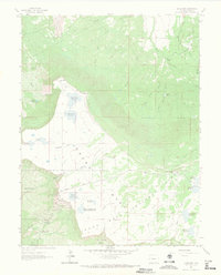
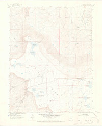
1962 Map of Lands End
USGS Topo · Published 1964About this map
Grand Mesa dominates this 1962 landscape, defined by a complex network of high-altitude water management and recreational infrastructure within the Grand Mesa National Forest. The map traces the winding ascent of Lands End Road, leading to the Lands End Overlook Picnic Ground, an observatory, and an airway beacon. This area serves as a critical watershed, evidenced by a dense concentration of small reservoirs such as Bolen Reservoir, the Vincent Res No 1, and the Robbins Reservoir. These features, alongside the historic Godding Grade and several jeep trails, illustrate how the mid-century terrain was utilized for both resource control and public access. Named campsites like Steamboat Rock Campground and the Wild Rose Picnic Ground further highlight the region's development for outdoor use during this era.
Find a feature on this map
45 named features on this map. Tap any name to fly to it.
Don’t see what you’re looking for? This feature index may not catch every label — zoom into the map to look around manually.
Map Details
Editions of this 1962 Lands End Map
4 editions found
Historical Maps of Mesa County Through Time
319 maps found

1934 Colorado National Monument
Mesa County, CO

1949 Calamity Mesa
Mesa County, CO

1949 Gateway
Mesa County, CO

1949 Juanita Arch
Mesa County, CO

1950 Calamity Mesa
Mesa County, CO

1950 Juanita Arch
Mesa County, CO

1950 Pine Mountain
Mesa County, CO

1952 Gateway
Mesa County, CO

1955 Cameo
Mesa County, CO

1955 Grand Mesa
Mesa County, CO

1955 Mesa Lakes
Mesa County, CO

1955 Mesa
Mesa County, CO

1955 Molina
Mesa County, CO

1955 Vega Reservoir
Mesa County, CO

1960 Calamity Mesa
Mesa County, CO

1960 Gateway
Mesa County, CO

1960 Gateway
Mesa County, CO

1960 Hawxhurst Creek
Mesa County, CO

1960 Juanita Arch
Mesa County, CO

1960 Pine Mountain
Mesa County, CO

1960 South Mamm Peak
Mesa County, CO

1961 Porter Mountain
Mesa County, CO

1961 Spruce Mountain
Mesa County, CO

1962 Battleship Rock
Mesa County, CO

1962 Colorado National Monument
Mesa County, CO

1962 Corcoran Point
Mesa County, CO

1962 Housetop Mountain
Mesa County, CO

1962 Lands End
Mesa County, CO

1962 Mack
Mesa County, CO

1962 Round Mountain
Mesa County, CO

1963 Flatiron Mountain
Mesa County, CO

1963 Hightower Mountain
Mesa County, CO

1963 Quaker Mesa
Mesa County, CO

1965 Indian Point
Mesa County, CO

1968 Badger Wash
Mesa County, CO

1968 Corcoran Peak
Mesa County, CO

1968 Highline Lake
Mesa County, CO

1968 Ruby Canyon
Mesa County, CO

1968 Ruby Lee Reservoir
Mesa County, CO

1968 Sieber Canyon
Mesa County, CO

1968 Wagon Track Ridge
Mesa County, CO

1968 Winter Flats
Mesa County, CO

1969 Bieser Creek
Mesa County, CO

1969 Glade Park
Mesa County, CO

1969 Island Mesa
Mesa County, CO

1969 Juniata Reservoir
Mesa County, CO

1969 Payne Wash
Mesa County, CO

1969 Triangle Mesa
Mesa County, CO

1969 Two V Basin
Mesa County, CO

1969 Whitewater
Mesa County, CO

1972 Casto Reservoir
Mesa County, CO

1972 Fish Creek
Mesa County, CO

1972 Jacks Canyon
Mesa County, CO

1972 Keith Creek
Mesa County, CO

1972 Snyder Flats
Mesa County, CO

1973 Escalante Forks
Mesa County, CO

1973 Kelso Point
Mesa County, CO

1973 Snipe Mountain
Mesa County, CO

1973 Uncompahgre Butte
Mesa County, CO

2010 Badger Wash
Mesa County, CO

2010 Battleship Rock
Mesa County, CO

2010 Bieser Creek
Mesa County, CO

2010 Cameo
Mesa County, CO

2010 Colorado National Monument
Mesa County, CO

2010 Corcoran Peak
Mesa County, CO

2010 Corcoran Point
Mesa County, CO

2010 Glade Park
Mesa County, CO

2010 Highline Lake
Mesa County, CO

2010 Island Mesa
Mesa County, CO

2010 Juanita Arch
Mesa County, CO

2010 Mack
Mesa County, CO

2010 Mesa
Mesa County, CO

2010 Payne Wash
Mesa County, CO

2010 Round Mountain
Mesa County, CO

2010 Ruby Canyon
Mesa County, CO

2010 Ruby Lee Reservoir
Mesa County, CO

2010 Sieber Canyon
Mesa County, CO

2010 Two V Basin
Mesa County, CO

2010 Wagon Track Ridge
Mesa County, CO

2010 Whitewater
Mesa County, CO

2010 Winter Flats
Mesa County, CO

2011 Calamity Mesa
Mesa County, CO

2011 Casto Reservoir
Mesa County, CO

2011 Dolores Point North
Mesa County, CO

2011 Dolores Point South
Mesa County, CO

2011 Escalante Forks
Mesa County, CO

2011 Fish Creek
Mesa County, CO

2011 Flatiron Mountain
Mesa County, CO

2011 Gateway
Mesa County, CO

2011 Grand Mesa
Mesa County, CO

2011 Hawxhurst Creek
Mesa County, CO

2011 Hightower Mountain
Mesa County, CO

2011 Housetop Mountain
Mesa County, CO

2011 Indian Point
Mesa County, CO

2011 Jacks Canyon
Mesa County, CO

2011 Juniata Reservoir
Mesa County, CO

2011 Keith Creek
Mesa County, CO

2011 Kelso Point
Mesa County, CO

2011 Lands End
Mesa County, CO

2011 Mesa Lakes
Mesa County, CO

2011 Molina
Mesa County, CO

2011 Pine Mountain
Mesa County, CO

2011 Porter Mountain
Mesa County, CO

2011 Quaker Mesa
Mesa County, CO

2011 Snipe Mountain
Mesa County, CO

2011 Snyder Flats
Mesa County, CO

2011 South Mamm Peak
Mesa County, CO

2011 Spruce Mountain
Mesa County, CO

2011 Triangle Mesa
Mesa County, CO

2011 Uncompahgre Butte
Mesa County, CO

2011 Vega Reservoir
Mesa County, CO

2013 Badger Wash
Mesa County, CO

2013 Battleship Rock
Mesa County, CO

2013 Bieser Creek
Mesa County, CO

2013 Calamity Mesa
Mesa County, CO

2013 Cameo
Mesa County, CO

2013 Casto Reservoir
Mesa County, CO

2013 Colorado National Monument
Mesa County, CO

2013 Corcoran Peak
Mesa County, CO

2013 Corcoran Point
Mesa County, CO

2013 Dolores Point North
Mesa County, CO

2013 Dolores Point South
Mesa County, CO

2013 Escalante Forks
Mesa County, CO

2013 Fish Creek
Mesa County, CO

2013 Flatiron Mountain
Mesa County, CO

2013 Gateway
Mesa County, CO

2013 Glade Park
Mesa County, CO

2013 Grand Mesa
Mesa County, CO

2013 Hawxhurst Creek
Mesa County, CO

2013 Highline Lake
Mesa County, CO

2013 Hightower Mountain
Mesa County, CO

2013 Housetop Mountain
Mesa County, CO

2013 Indian Point
Mesa County, CO

2013 Island Mesa
Mesa County, CO

2013 Jacks Canyon
Mesa County, CO

2013 Juanita Arch
Mesa County, CO

2013 Juniata Reservoir
Mesa County, CO

2013 Keith Creek
Mesa County, CO

2013 Kelso Point
Mesa County, CO

2013 Lands End
Mesa County, CO

2013 Mack
Mesa County, CO

2013 Mesa Lakes
Mesa County, CO

2013 Mesa
Mesa County, CO

2013 Molina
Mesa County, CO

2013 Payne Wash
Mesa County, CO

2013 Pine Mountain
Mesa County, CO

2013 Porter Mountain
Mesa County, CO

2013 Quaker Mesa
Mesa County, CO

2013 Round Mountain
Mesa County, CO

2013 Ruby Canyon
Mesa County, CO

2013 Ruby Lee Reservoir
Mesa County, CO

2013 Sieber Canyon
Mesa County, CO

2013 Snipe Mountain
Mesa County, CO

2013 Snyder Flats
Mesa County, CO

2013 South Mamm Peak
Mesa County, CO

2013 Spruce Mountain
Mesa County, CO

2013 Triangle Mesa
Mesa County, CO

2013 Two V Basin
Mesa County, CO

2013 Uncompahgre Butte
Mesa County, CO

2013 Vega Reservoir
Mesa County, CO

2013 Wagon Track Ridge
Mesa County, CO

2013 Whitewater
Mesa County, CO

2013 Winter Flats
Mesa County, CO

2016 Badger Wash
Mesa County, CO

2016 Battleship Rock
Mesa County, CO

2016 Bieser Creek
Mesa County, CO

2016 Calamity Mesa
Mesa County, CO

2016 Cameo
Mesa County, CO

2016 Casto Reservoir
Mesa County, CO

2016 Colorado National Monument
Mesa County, CO

2016 Corcoran Peak
Mesa County, CO

2016 Corcoran Point
Mesa County, CO

2016 Dolores Point North
Mesa County, CO

2016 Dolores Point South
Mesa County, CO

2016 Escalante Forks
Mesa County, CO

2016 Fish Creek
Mesa County, CO

2016 Flatiron Mountain
Mesa County, CO

2016 Gateway
Mesa County, CO

2016 Glade Park
Mesa County, CO

2016 Grand Mesa
Mesa County, CO

2016 Hawxhurst Creek
Mesa County, CO

2016 Highline Lake
Mesa County, CO

2016 Hightower Mountain
Mesa County, CO

2016 Housetop Mountain
Mesa County, CO

2016 Indian Point
Mesa County, CO

2016 Island Mesa
Mesa County, CO

2016 Jacks Canyon
Mesa County, CO

2016 Juanita Arch
Mesa County, CO

2016 Juniata Reservoir
Mesa County, CO

2016 Keith Creek
Mesa County, CO

2016 Kelso Point
Mesa County, CO

2016 Lands End
Mesa County, CO

2016 Mack
Mesa County, CO

2016 Mesa Lakes
Mesa County, CO

2016 Mesa
Mesa County, CO

2016 Molina
Mesa County, CO

2016 Payne Wash
Mesa County, CO

2016 Pine Mountain
Mesa County, CO

2016 Porter Mountain
Mesa County, CO

2016 Quaker Mesa
Mesa County, CO

2016 Round Mountain
Mesa County, CO

2016 Ruby Canyon
Mesa County, CO

2016 Ruby Lee Reservoir
Mesa County, CO

2016 Sieber Canyon
Mesa County, CO

2016 Snipe Mountain
Mesa County, CO

2016 Snyder Flats
Mesa County, CO

2016 South Mamm Peak
Mesa County, CO

2016 Spruce Mountain
Mesa County, CO

2016 Triangle Mesa
Mesa County, CO

2016 Two V Basin
Mesa County, CO

2016 Uncompahgre Butte
Mesa County, CO

2016 Vega Reservoir
Mesa County, CO

2016 Wagon Track Ridge
Mesa County, CO

2016 Whitewater
Mesa County, CO

2016 Winter Flats
Mesa County, CO

2019 Badger Wash
Mesa County, CO

2019 Battleship Rock
Mesa County, CO

2019 Bieser Creek
Mesa County, CO

2019 Calamity Mesa
Mesa County, CO

2019 Cameo
Mesa County, CO

2019 Casto Reservoir
Mesa County, CO

2019 Colorado National Monument
Mesa County, CO

2019 Corcoran Peak
Mesa County, CO

2019 Corcoran Point
Mesa County, CO

2019 Dolores Point North
Mesa County, CO

2019 Dolores Point South
Mesa County, CO

2019 Escalante Forks
Mesa County, CO

2019 Fish Creek
Mesa County, CO

2019 Flatiron Mountain
Mesa County, CO

2019 Gateway
Mesa County, CO

2019 Glade Park
Mesa County, CO

2019 Grand Mesa
Mesa County, CO

2019 Hawxhurst Creek
Mesa County, CO

2019 Highline Lake
Mesa County, CO

2019 Hightower Mountain
Mesa County, CO

2019 Housetop Mountain
Mesa County, CO

2019 Indian Point
Mesa County, CO

2019 Island Mesa
Mesa County, CO

2019 Jacks Canyon
Mesa County, CO

2019 Juanita Arch
Mesa County, CO

2019 Juniata Reservoir
Mesa County, CO

2019 Keith Creek
Mesa County, CO

2019 Kelso Point
Mesa County, CO

2019 Lands End
Mesa County, CO

2019 Mack
Mesa County, CO

2019 Mesa Lakes
Mesa County, CO

2019 Mesa
Mesa County, CO

2019 Molina
Mesa County, CO

2019 Payne Wash
Mesa County, CO

2019 Pine Mountain
Mesa County, CO

2019 Porter Mountain
Mesa County, CO

2019 Quaker Mesa
Mesa County, CO

2019 Round Mountain
Mesa County, CO

2019 Ruby Canyon
Mesa County, CO

2019 Ruby Lee Reservoir
Mesa County, CO

2019 Sieber Canyon
Mesa County, CO

2019 Snipe Mountain
Mesa County, CO

2019 Snyder Flats
Mesa County, CO

2019 South Mamm Peak
Mesa County, CO

2019 Spruce Mountain
Mesa County, CO

2019 Triangle Mesa
Mesa County, CO

2019 Two V Basin
Mesa County, CO

2019 Uncompahgre Butte
Mesa County, CO

2019 Vega Reservoir
Mesa County, CO

2019 Wagon Track Ridge
Mesa County, CO

2019 Whitewater
Mesa County, CO

2019 Winter Flats
Mesa County, CO

2022 Badger Wash
Mesa County, CO

2022 Battleship Rock
Mesa County, CO

2022 Bieser Creek
Mesa County, CO

2022 Calamity Mesa
Mesa County, CO

2022 Cameo
Mesa County, CO

2022 Casto Reservoir
Mesa County, CO

2022 Corcoran Peak
Mesa County, CO

2022 Corcoran Point
Mesa County, CO

2022 Dolores Point North
Mesa County, CO

2022 Dolores Point South
Mesa County, CO

2022 Escalante Forks
Mesa County, CO

2022 Fish Creek
Mesa County, CO

2022 Flatiron Mountain
Mesa County, CO

2022 Gateway
Mesa County, CO

2022 Glade Park
Mesa County, CO

2022 Grand Mesa
Mesa County, CO

2022 Hawxhurst Creek
Mesa County, CO

2022 Highline Lake
Mesa County, CO

2022 Hightower Mountain
Mesa County, CO

2022 Housetop Mountain
Mesa County, CO

2022 Indian Point
Mesa County, CO

2022 Island Mesa
Mesa County, CO

2022 Jacks Canyon
Mesa County, CO

2022 Juanita Arch
Mesa County, CO

2022 Juniata Reservoir
Mesa County, CO

2022 Keith Creek
Mesa County, CO

2022 Kelso Point
Mesa County, CO

2022 Lands End
Mesa County, CO

2022 Mack
Mesa County, CO

2022 Mesa Lakes
Mesa County, CO

2022 Mesa
Mesa County, CO

2022 Molina
Mesa County, CO

2022 Payne Wash
Mesa County, CO

2022 Pine Mountain
Mesa County, CO

2022 Porter Mountain
Mesa County, CO

2022 Quaker Mesa
Mesa County, CO

2022 Round Mountain
Mesa County, CO

2022 Ruby Canyon
Mesa County, CO

2022 Ruby Lee Reservoir
Mesa County, CO

2022 Sieber Canyon
Mesa County, CO

2022 Snipe Mountain
Mesa County, CO

2022 Snyder Flats
Mesa County, CO

2022 South Mamm Peak
Mesa County, CO

2022 Spruce Mountain
Mesa County, CO

2022 Triangle Mesa
Mesa County, CO

2022 Two V Basin
Mesa County, CO

2022 Uncompahgre Butte
Mesa County, CO

2022 Vega Reservoir
Mesa County, CO

2022 Wagon Track Ridge
Mesa County, CO

2022 Whitewater
Mesa County, CO

2022 Winter Flats
Mesa County, CO

2023 Colorado National Monument
Mesa County, CO