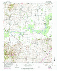
1952 Map of Lane
USGS Topo · Published 1984About this map
Obion River meanders across the center of this mid-century West Tennessee landscape, defining the boundary between Obion and Dyer counties. The river's historical path is evidenced by numerous oxbow formations and cutoff features such as Old River Lake, Goose Lake, and Horseshoe Lake. The topography is a study in the transition from the fertile river bottoms of Maple Bend to the rising hills in the south, where Biffle Creek and Town Creek cut through the terrain toward Newbern.
Find a feature on this map
30 named features on this map. Tap any name to fly to it.
Don’t see what you’re looking for? This feature index may not catch every label — zoom into the map to look around manually.
Map Details
Editions of this 1952 Lane Map
2 editions found
Other maps of this area

1925 · Reelfoot Lake
USGS Topo · 1:62,500

1939 · Reelfoot Lake
USGS Topo · 1:62,500

1939 · Dyersburg
USGS Topo · 1:62,500

1950 · Obion
USGS Topo · 1:24,000

1951 · Obion
USGS Topo · 1:24,000

1952 · Newbern
USGS Topo · 1:24,000

1952 · Lane
USGS Topo · 1:24,000

1952 · Dyersburg
USGS Topo · 1:24,000

1952 · Miston
USGS Topo · 1:24,000

1956 · Reelfoot Lake
USGS Topo · 1:62,500