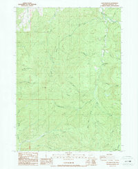
1987 Map of Lane Mountain
USGS Topo · Published 1987About this map
Lane Mountain and Buck Peak define the high elevations of this Douglas County landscape during the late 1980s. The terrain is deeply carved by a network of drainage systems, including South Fork Deer Creek and North Myrtle Creek. Significant infrastructure for both communication and recreation is documented, from the Lane Radio Facility perched on the heights to the Covered Bridge and Cavitt Creek Park found near the water.
Find a feature on this map
30 named features on this map. Tap any name to fly to it.
Don’t see what you’re looking for? This feature index may not catch every label — zoom into the map to look around manually.
Map Details
Editions of this 1987 Lane Mountain Map
This is the sole edition of this map. No revisions or reprints were ever made.
Other maps of this area

1897 · Roseburg
USGS Topo · 1:125,000

1900 · Roseburg
USGS Topo · 1:125,000

1954 · Dixonville
USGS Topo · 1:62,500

1954 · Glide
USGS Topo · 1:62,500

1955 · Red Butte
USGS Topo · 1:62,500

1955 · Mace Mtn
USGS Topo · 1:62,500

1958 · Roseburg
USGS Topo · 1:250,000

1959 · Roseburg
USGS Topo · 1:250,000

1978 · Diamond Lake
USGS Topo · 1:100,000

1979 · Roseburg
USGS Topo · 1:100,000