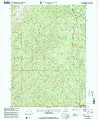
1998 Map of Lane Mountain
USGS Topo · Published 2000About this map
Lane Mountain and Buck Peak anchor this Douglas County landscape within the Umpqua National Forest. The topography is defined by the drainage basins of the Little River and Cavitt Creek, where land management is split between national forest service and Bureau of Land Management interests at the Cavitt Creek Falls Recreation Area. Local infrastructure is represented by a Covered Bridge crossing the river and the Lane Mountain Communication Facility at the summit. A network of 4wd roads and trails provides access to interior landmarks like the Cavitt Shelter and a remote Quarry. The map illustrates the complex drainage of the Cascade foothills, showing the headwaters of numerous creeks including Buck Fork and the North Fork Myrtle Creek as they flow through these timberlands at the close of the twentieth century.
Find a feature on this map
30 named features on this map. Tap any name to fly to it.
Don’t see what you’re looking for? This feature index may not catch every label — zoom into the map to look around manually.
Map Details
Editions of this 1998 Lane Mountain Map
This is the sole edition of this map. No revisions or reprints were ever made.
Other maps of this area

1897 · Roseburg
USGS Topo · 1:125,000

1900 · Roseburg
USGS Topo · 1:125,000

1954 · Dixonville
USGS Topo · 1:62,500

1954 · Glide
USGS Topo · 1:62,500

1955 · Red Butte
USGS Topo · 1:62,500

1955 · Mace Mtn
USGS Topo · 1:62,500

1958 · Roseburg
USGS Topo · 1:250,000

1959 · Roseburg
USGS Topo · 1:250,000

1978 · Diamond Lake
USGS Topo · 1:100,000

1979 · Roseburg
USGS Topo · 1:100,000