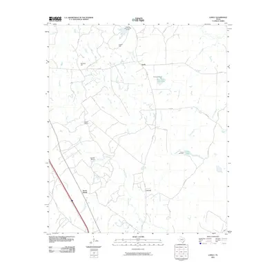
2010 Map of Lanely
USGS Topo · Published 2010About this map
Harrison Chapel Cemetery and the settlement of Lanely define the central character of this East Texas landscape, where rural life is shaped by the winding tributaries of the Trinity River basin. In the early 21st century, the area remains dominated by agricultural networks and small communities like Concord and Marshy Springs. The terrain is punctuated by significant landmarks such as Burleson Hill and the Folsom Hills, while the lowlands of Chandler Bottom are fed by the waters of Browns Creek. Local water management is visible through features like the Plum Creek Ranch Dam and Snider Lake Dam, reflecting the region's reliance on ranching and private water resources. The intricate grid of farm-to-market roads and county routes, such as FM 489 and FM 1848, illustrates the enduring connectivity of these Freestone County locales.
Find a feature on this map
39 named features on this map. Tap any name to fly to it.
Don’t see what you’re looking for? This feature index may not catch every label — zoom into the map to look around manually.
Map Details
Editions of this 2010 Lanely Map
This is the sole edition of this map. No revisions or reprints were ever made.
Other maps of this area

1919 · Fairfield
USGS Topo · 1:62,500

1953 · Palestine
USGS Topo · 1:250,000

1954 · Waco
USGS Topo · 1:250,000

1955 · Waco
USGS Topo · 1:250,000

1956 · Jewett
USGS Topo · 1:62,500

1957 · Palestine
USGS Topo · 1:250,000

1964 · Flo
USGS Topo · 1:24,000

1964 · Keechi
USGS Topo · 1:24,000
1964 · Butler
USGS Topo · 1:24,000

1965 · Dew
USGS Topo · 1:24,000