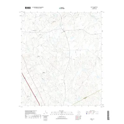
2019 Map of Lanely
USGS Topo · Published 2019About this map
Harrison Chapel Cem and Holly Grove Cem serve as quiet landmarks in this rural pocket of East Texas, reflecting the deep-rooted family history of Freestone and Leon Counties. The small settlement of Lanely sits at the junction of FM 489 and FM 1848, surrounded by a landscape defined by prominent elevations such as Burleson Hill and the Folsom Hills. The local geography is intricately carved by numerous waterways, including Upper Keechi Cr, Plum Cr, and the low-lying Chandler Bottom. To the southwest, Fulks Dugout and Whitney Br highlight the specialized local names given to the creeks and drainage features that feed into Mustang Cr near the county line. This 2019 survey documents a network of county roads and ranch paths that connect these dispersed homesteads and natural landmarks, preserving the layout of the region's agricultural and ranching heritage.
Find a feature on this map
50 named features on this map. Tap any name to fly to it.
Don’t see what you’re looking for? This feature index may not catch every label — zoom into the map to look around manually.
Map Details
Editions of this 2019 Lanely Map
This is the sole edition of this map. No revisions or reprints were ever made.
Other maps of this area

1919 · Fairfield
USGS Topo · 1:62,500

1953 · Palestine
USGS Topo · 1:250,000

1954 · Waco
USGS Topo · 1:250,000

1955 · Waco
USGS Topo · 1:250,000

1956 · Jewett
USGS Topo · 1:62,500

1957 · Palestine
USGS Topo · 1:250,000

1964 · Flo
USGS Topo · 1:24,000

1964 · Keechi
USGS Topo · 1:24,000
1964 · Butler
USGS Topo · 1:24,000

1965 · Dew
USGS Topo · 1:24,000