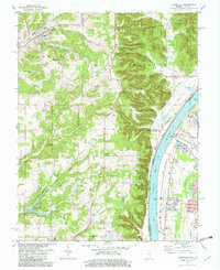
1982 Map of Lanesville
USGS Topo · Published 1982About this map
Lanesville serves as the primary hub of this 1982 survey, nestled north of the significant ridges that define the Harrison County landscape. The town's institutional history is evident through features like St Marys Sch and the Lanesville Cem, while the nearby Lanesville Skyways Airport highlights local transportation infrastructure. Southward, the terrain transitions into a series of prominent ridges, including Riley Ridge, Sampson Ridge, and Backbone Ridge, which separate the inland creek valleys from the Ohio River. Along the river's edge, small riverside communities like Bridgeport, Locust Point, and Greenwood occupy the narrow strip between the water and the bluffs. Genealogists will find a wealth of family-named landmarks and cemeteries scattered across the rural townships, such as Lottick Corner, Kingery Cem, and Shoemaker Cem, documenting the area's deep-rooted settlement patterns during the early 1980s.
Find a feature on this map
73 named features on this map. Tap any name to fly to it.
Don’t see what you’re looking for? This feature index may not catch every label — zoom into the map to look around manually.
Map Details
Editions of this 1982 Lanesville Map
2 editions found
Other maps of this area

1909 · Kosmosdale
USGS Topo · 1:48,000

1912 · Kosmosdale
USGS Topo · 1:62,500

1931 · Corydon
USGS Topo · 1:62,500

1939 · New Albany
USGS Topo · 1:24,000

1939 · Georgetown
USGS Topo · 1:24,000

1946 · New Albany
USGS Topo · 1:24,000

1947 · Georgetown
USGS Topo · 1:24,000

1948 · Corydon East
USGS Topo · 1:24,000

1948 · Laconia
USGS Topo · 1:24,000

1949 · Georgetown
USGS Topo · 1:24,000