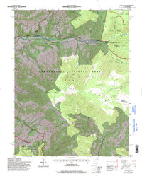
1995 Map of Laneville
USGS Topo · Published 1998About this map
Laneville and the small settlement of Canaan Crossing sit at the northern edge of this high-elevation landscape, where the Dry Fork District of Randolph County meets Tucker and Pendleton counties. The map captures the meeting point of several major conservation areas, including the Dolly Sods Wilderness, Canaan Valley State Park, and the Monongahela National Forest. Notable landmarks such as Mt Porte Crayon, Thunderstruck Rock, and the expansive Flat Rock Plains dominate the central terrain.
Find a feature on this map
53 named features on this map. Tap any name to fly to it.
Don’t see what you’re looking for? This feature index may not catch every label — zoom into the map to look around manually.
Map Details
Editions of this 1995 Laneville Map
This is the sole edition of this map. No revisions or reprints were ever made.
Other maps of this area

1886 · St. George
USGS Topo · 1:125,000

1889 · Beverly
USGS Topo · 1:125,000

1891 · St. George
USGS Topo · 1:125,000

1892 · Beverly
USGS Topo · 1:125,000

1892 · Franklin
USGS Topo · 1:125,000

1895 · Piedmont
USGS Topo · 1:125,000

1896 · Franklin
USGS Topo · 1:125,000

1908 · Parsons
USGS Topo · 1:62,500

1916 · Davis
USGS Topo · 1:48,000

1918 · Davis
USGS Topo · 1:62,500