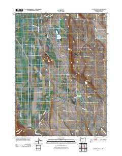
2011 Map of Langell Valley
USGS Topo · Published 2011About this map
Langell Valley is defined by a complex irrigation and water management network along the winding Lost River. This Klamath County landscape utilizes the Malone Dam and the Malone Diversion Dam to channel water through the East Malone Lateral and other canals, supporting the agricultural life of the valley floor. The surrounding terrain is marked by significant hydrological features and landmarks such as Gift Butte and the wide expanse of Willow Valley. In the northern and eastern reaches, smaller water bodies like Boggs Lake and Copeland Reservoir sit alongside rugged breaks including Woolen Canyon. The presence of Heffner Spring and Woolen Canyon Spring underscores the importance of every water source in this high-desert environment, while Threemile Reservoir and Threemile Flat illustrate the seasonal and managed nature of the regional drainage basins.
Find a feature on this map
25 named features on this map. Tap any name to fly to it.
Don’t see what you’re looking for? This feature index may not catch every label — zoom into the map to look around manually.
Map Details
Editions of this 2011 Langell Valley Map
This is the sole edition of this map. No revisions or reprints were ever made.
Other maps of this area

1886 · Modoc Lava Bed
USGS Topo · 1:250,000

1889 · Klamath
USGS Topo · 1:250,000

1892 · Modoc Lava-Bed
USGS Topo · 1:250,000

1894 · Klamath
USGS Topo · 1:250,000

1951 · Clear Lake Reservoir
USGS Topo · 1:62,500

1951 · Tulelake
USGS Topo · 1:62,500

1954 · Alturas
USGS Topo · 1:250,000

1955 · Klamath Falls
USGS Topo · 1:250,000

1957 · Malin
USGS Topo · 1:62,500

1958 · Alturas
USGS Topo · 1:250,000