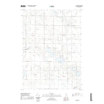
2019 Map of Langston
USGS Topo · Published 2019About this map
Clifford Lake and Dickerson Lake sit at the center of this rural landscape in Montcalm County, where the Flat River winds through a terrain defined by numerous glacial lakes and wetlands. The settlement of Langston occupies a junction in the west, while Sidney and Entrican anchor the southeast and northeast corners respectively. This agricultural and lakeside region is dotted with local burial grounds, including the Sidney Township Cem and Riverside Cem, reflecting generations of family history in Sidney Township. The map shows a dense network of county roads like Co Rd 530 and Co Rd 522 that connect the small hamlets and waterfront properties. Water bodies such as Turk Lake, Pickel Lake, and Derby Lake illustrate the lake-dense character of this Michigan interior, where drainage through Dickerson Cr shapes the local topography.
Find a feature on this map
82 named features on this map. Tap any name to fly to it.
Don’t see what you’re looking for? This feature index may not catch every label — zoom into the map to look around manually.
Map Details
Editions of this 2019 Langston Map
This is the sole edition of this map. No revisions or reprints were ever made.
Other maps of this area

1954 · Midland
USGS Topo · 1:250,000

1958 · Midland
USGS Topo · 1:250,000

1959 · Midland
USGS Topo · 1:250,000

1959 · Howard City
USGS Topo · 1:62,500

1964 · Edmore
USGS Topo · 1:24,000

1964 · Six Lakes
USGS Topo · 1:24,000

1964 · Langston
USGS Topo · 1:24,000

1964 · Stanton
USGS Topo · 1:24,000

1966 · Midland
USGS Topo · 1:250,000

1972 · Greenville West
USGS Topo · 1:24,000