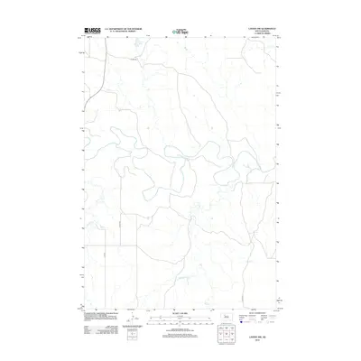
2012 Map of Lantry NW
USGS Topo · Published 2012About this map
The meandering Moreau River defines this landscape in Ziebach County, cutting a winding path through the northern plains of South Dakota. This 2012 survey documents a largely open territory where water resources are central to the geography, evidenced by features such as Jewitt Pond and the drainage patterns of Pretty Cr and Bear Cr. The infrastructure consists of a sparse network of county roads, including Co Hwy-22 and Co Hwy-2d, which connect the isolated rangeland. The map illustrates the characteristic section-line grid typical of the Great Plains, showing how modern transportation routes like Highway 65 integrate with the natural topography of the river basin.
Find a feature on this map
9 named features on this map. Tap any name to fly to it.
Don’t see what you’re looking for? This feature index may not catch every label — zoom into the map to look around manually.
Map Details
Editions of this 2012 Lantry NW Map
This is the sole edition of this map. No revisions or reprints were ever made.
Other maps of this area

1951 · Dupree NE
USGS Topo · 1:24,000

1952 · Lantry NW
USGS Topo · 1:24,000

1952 · Lantry NE
USGS Topo · 1:24,000

1953 · McIntosh
USGS Topo · 1:250,000

1958 · McIntosh
USGS Topo · 1:250,000

1978 · Isabel SW
USGS Topo · 1:24,000

1978 · Peach Lake
USGS Topo · 1:24,000

1979 · Dupree
USGS Topo · 1:25,000

1981 · Lantry
USGS Topo · 1:24,000
1981 · Lantry SE
USGS Topo · 1:24,000