
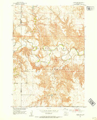
1952 Map of Lantry NW
USGS Topo · Published 1954About this map
The Cheyenne Indian Reservation dominates this mid-century landscape in the Missouri River Basin, where the meandering path of the Moreau River carves through the central plains. Remote one-room schoolhouses like Liebelt Sch and O Donnell Sch serve as the primary markers of settlement in this sparsely populated region of South Dakota. The topography is defined by the complex drainage systems of Pretty Creek and Bear Creek, which feed into the river valley. Surveyed in the early 1950s, the map reveals a quiet, rural interior where small water bodies like Jewitt Pond and the shared boundary between Ziebach County and Dewey County provided the essential geographic framework for local residents and ranchers.
Find a feature on this map
8 named features on this map. Tap any name to fly to it.
Don’t see what you’re looking for? This feature index may not catch every label — zoom into the map to look around manually.
Map Details
Editions of this 1952 Lantry NW Map
2 editions found
Other maps of this area

1951 · Dupree NE
USGS Topo · 1:24,000

1952 · Lantry NE
USGS Topo · 1:24,000

1953 · McIntosh
USGS Topo · 1:250,000

1958 · McIntosh
USGS Topo · 1:250,000

1978 · Isabel SW
USGS Topo · 1:24,000

1978 · Peach Lake
USGS Topo · 1:24,000

1979 · Dupree
USGS Topo · 1:25,000

1981 · Lantry
USGS Topo · 1:24,000
1981 · Lantry SE
USGS Topo · 1:24,000
1982 · Irish Creek SE
USGS Topo · 1:24,000