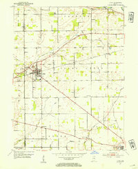
1953 Map of Lapel
USGS Topo · Published 1954About this map
Lapel serves as a primary hub of activity in this 1950s depiction of Madison County, where the Central Indiana railroad intersects the town's grid. The industrial character of the area is highlighted by a large Limestone Quarry located just west of the main settlement. Further west, the small community of Fishersburg sits along the banks of Stony Creek, while Beall Chapel and the Old Woodward Cem offer evidence of the rural social and family structures that shaped the landscape. Rural life is further documented by the presence of the Township Sch and several remote burial grounds like Nicholson Cem and Pleasant Valley Cem. The map captures a transition as established transport lines like the Central Indiana rail route pass through agrarian areas and small stops like Bloomer and Hardscrabble, connecting the agricultural hinterland to larger markets.
Find a feature on this map
28 named features on this map. Tap any name to fly to it.
Don’t see what you’re looking for? This feature index may not catch every label — zoom into the map to look around manually.
Map Details
Editions of this 1953 Lapel Map
2 editions found
Other maps of this area

1952 · Ingalls
USGS Topo · 1:24,000

1952 · Mc Cordsville
USGS Topo · 1:24,000

1952 · Anderson
USGS Topo · 1:24,000

1953 · Pendleton
USGS Topo · 1:24,000

1953 · Lapel
USGS Topo · 1:24,000

1953 · Riverwood
USGS Topo · 1:24,000

1953 · Cincinnati
USGS Topo · 1:250,000

1953 · Muncie
USGS Topo · 1:250,000

1956 · Muncie
USGS Topo · 1:250,000

1957 · Cincinnati
USGS Topo · 1:250,000