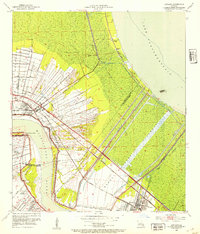
1952 Map of Laplace
USGS Topo · Published 1953About this map
Industrial expansion and river management dominate this early 1950s survey of the river parishes, where the massive Bonnet Carre Spillway and Bonnet Carre Floodway carve a wide path between the Mississippi River and Lake Pontchartrain. The landscape reveals a transition from traditional agriculture to heavy industry, with established riverfront sites like Glen Dale Plantation and Trinity Plantation neighboring a large Oil Refinery near Sellers. The settlement of Laplace serves as a transportation hub where the Illinois Central Railroad and Kansas City Southern Railroad intersect with the Airline Highway. Local landmarks such as the Hymelia Crevasse and Old Killona Sch provide valuable reference points for genealogists tracing family history along the St. John the Baptist and St. Charles Parish line.
Find a feature on this map
29 named features on this map. Tap any name to fly to it.
Don’t see what you’re looking for? This feature index may not catch every label — zoom into the map to look around manually.
Map Details
Editions of this 1952 Laplace Map
This is the sole edition of this map. No revisions or reprints were ever made.
Other maps of this area

1891 · Hahnville
USGS Topo · 1:62,500

1892 · Lac Des Allemands
USGS Topo · 1:62,500

1892 · Mount Airy
USGS Topo · 1:62,500

1892 · Bonnet Carre
USGS Topo · 1:62,500

1932 · Hahnville NW
USGS Topo · 1:31,680

1932 · Lac Des Allemands NE
USGS Topo · 1:31,680

1932 · Hahnville NE
USGS Topo · 1:31,680

1935 · Laplace
USGS Topo · 1:31,680

1935 · Luling
USGS Topo · 1:31,680

1936 · Hahnville
USGS Topo · 1:31,680