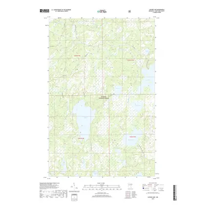
2019 Map of Lapond Lake
USGS Topo · Published 2019About this map
Superior National Forest dominates this landscape, preserving a dense network of water bodies and recreational paths in the Minnesota Northwoods. The area is defined by its glacial hydrology, with large basins like Big Moose Lake and Big Rice Lake connected by the winding Portage River and Duck Creek. Transportation through this wilderness is largely restricted to established backcountry routes such as the Echo Trail and the Moose Loop. These trails often follow historic portage routes and timber access paths. While the map is primarily a record of natural features, the presence of the Kessanen Pit near the northern edge provides evidence of local mineral extraction or road material sourcing within the forest. The intricate shoreline of Lapond Lake and the surrounding wetlands illustrate the complex drainage patterns characteristic of Saint Louis County's lake country.
Find a feature on this map
27 named features on this map. Tap any name to fly to it.
Don’t see what you’re looking for? This feature index may not catch every label — zoom into the map to look around manually.
Map Details
Editions of this 2019 Lapond Lake Map
This is the sole edition of this map. No revisions or reprints were ever made.
Other maps of this area

1933 · Ely
USGS Topo · 1:62,500

1939 · Ely
USGS Topo · 1:62,500

1954 · Two Harbors
USGS Topo · 1:250,000

1954 · Hibbing
USGS Topo · 1:250,000

1954 · International Falls
USGS Topo · 1:250,000

1956 · Chad Lake
USGS Topo · 1:24,000

1956 · Crab Lake
USGS Topo · 1:24,000

1957 · Two Harbors
USGS Topo · 1:250,000

1957 · Hibbing
USGS Topo · 1:250,000

1957 · International Falls
USGS Topo · 1:250,000