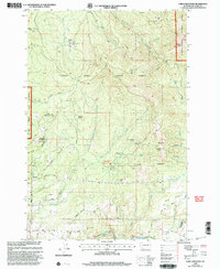
2000 Map of Larch Mountain
USGS Topo · Published 2003About this map
Yacolt Burn State Forest and the Gifford Pinchot National Forest dominate this landscape on the cusp of the millennium. The map documents a transition between protected woodlands and the encroaching development near the Camp Bonneville Military Reservation and settlements like Ireland and Creswell Heights. High points such as Larch Mtn, Elkhorn Mtn, and Spud Mountain provide significant verticality, while the Washougal River and its numerous tributaries, including Jones Creek and the Lacamas Creek East Fork, drain the watershed. The presence of the Larch Corrections Center and a Communication Site at the summit of Larch Mountain reflects the area's modern infrastructure. For those interested in recreation and local topography, the Tarbell Trail and Jones Creek Picnic Area are clearly marked alongside numerous 4WD roads and local routes like Stauffer Road and Ammeter Road.
Find a feature on this map
49 named features on this map. Tap any name to fly to it.
Don’t see what you’re looking for? This feature index may not catch every label — zoom into the map to look around manually.
Map Details
Editions of this 2000 Larch Mountain Map
This is the sole edition of this map. No revisions or reprints were ever made.
Other maps of this area

1918 · Troutdale
USGS Topo · 1:62,500

1934 · Troutdale
USGS Topo · 1:48,000

1940 · Lookout Mtn
USGS Topo · 1:62,500

1941 · Yacolt
USGS Topo · 1:62,500

1941 · Camas
USGS Topo · 1:62,500

1942 · Camas
USGS Topo · 1:62,500

1948 · Vancouver
USGS Topo · 1:250,000

1950 · Vancouver
USGS Topo · 1:250,000

1950 · Vancouver
USGS Topo · 1:250,000

1953 · Lookout Mtn
USGS Topo · 1:62,500