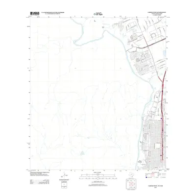
2013 Map of Laredo West
USGS Topo · Published 2013About this map
The Rio Grande serves as the international boundary and the primary geographic driver for the Laredo area on this 2013 survey. The river's winding course defines the landscape, from the higher ground at El Pico in the northwest down toward the historic military grounds of Fort McIntosh. The map documents a significant era of expansion, where residential developments like La Bota Ranch sit alongside massive commercial hubs such as the Killam Industrial Blvd corridor. The layout illustrates the shift from early settlement patterns near the water to modern logistics and infrastructure.
Find a feature on this map
89 named features on this map. Tap any name to fly to it.
Don’t see what you’re looking for? This feature index may not catch every label — zoom into the map to look around manually.
Map Details
Editions of this 2013 Laredo West Map
This is the sole edition of this map. No revisions or reprints were ever made.
Other maps of this area

1933 · Becerra Creek
USGS Topo · 1:62,500

1956 · Islitas
USGS Topo · 1:62,500

1956 · Laredo East
USGS Topo · 1:62,500

1956 · Laredo
USGS Topo · 1:250,000

1965 · Laredo West
USGS Topo · 1:24,000

1965 · Orvil
USGS Topo · 1:24,000

1965 · Cuervo Creek
USGS Topo · 1:24,000
1965 · Dolores Ranch
USGS Topo · 1:24,000

1965 · Laredo East
USGS Topo · 1:24,000

1979 · Laredo South
USGS Topo · 1:24,000