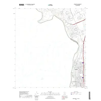
2019 Map of Laredo West
USGS Topo · Published 2019About this map
Fort McIntosh stands near the sharp bend of the Rio Grande, anchoring the southwestern edge of this international border landscape. The map captures the urban transition of Laredo as it reaches northward along the river and major thoroughfares. Modern industrial development is prominent along the Killam Industrial Blvd corridor, while the residential and commercial spread of Nye fills the eastern portion of the sheet. Natural drainages like Sombrerito Cr and Zacata Cr cut through the terrain, contrasting with the engineered layout of the Bob Bullock Loop. This edition illustrates a unique intersection of military history, modern logistics, and natural geography, showing the United States and Mexico border in high detail. Significant infrastructure like the Old Mines Rd hints at the region's long-standing connection to resource extraction and transportation north of the city center.
Find a feature on this map
135 named features on this map. Tap any name to fly to it.
Don’t see what you’re looking for? This feature index may not catch every label — zoom into the map to look around manually.
Map Details
Editions of this 2019 Laredo West Map
This is the sole edition of this map. No revisions or reprints were ever made.
Other maps of this area

1933 · Becerra Creek
USGS Topo · 1:62,500

1956 · Islitas
USGS Topo · 1:62,500

1956 · Laredo East
USGS Topo · 1:62,500

1956 · Laredo
USGS Topo · 1:250,000

1965 · Laredo West
USGS Topo · 1:24,000

1965 · Orvil
USGS Topo · 1:24,000

1965 · Cuervo Creek
USGS Topo · 1:24,000
1965 · Dolores Ranch
USGS Topo · 1:24,000

1965 · Laredo East
USGS Topo · 1:24,000

1979 · Laredo South
USGS Topo · 1:24,000