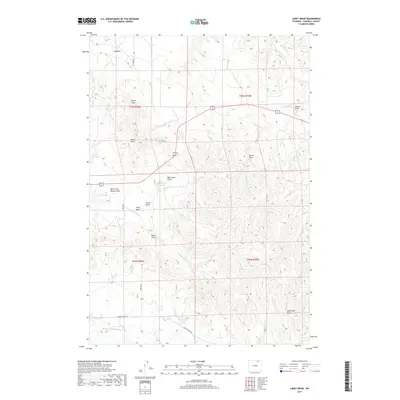
2017 Map of Larey Draw
USGS Topo · Published 2017About this map
Spotted Horse Cr and its various forks define the drainage patterns of this rural Campbell County landscape, where the high plains are carved by an intricate network of draws. Water management is central to the land's utility, evidenced by the presence of Okeson Reservoir and Fitzgerald Reservoir, which capture runoff in an otherwise arid environment. The topography is marked by family-named or descriptive landmarks such as Larey Draw, Big Coulee Draw, and Dead Calf Draw, providing a glimpse into the ranching heritage of the region. Transportation follows the natural contours and section lines, with routes like Barton Rd and S A Rd connecting isolated points across the township and range boundaries. The map illustrates a contemporary view of the N Prong Wild Horse Cr basin, showing how modern land divisions overlay the ancient, eroded terrain of the Wyoming basin.
Find a feature on this map
27 named features on this map. Tap any name to fly to it.
Don’t see what you’re looking for? This feature index may not catch every label — zoom into the map to look around manually.
Map Details
Editions of this 2017 Larey Draw Map
This is the sole edition of this map. No revisions or reprints were ever made.
Other maps of this area

1954 · Gillette
USGS Topo · 1:250,000

1955 · Sheridan
USGS Topo · 1:250,000

1955 · Gillette
USGS Topo · 1:250,000

1958 · Gillette
USGS Topo · 1:250,000

1958 · Sheridan
USGS Topo · 1:250,000

1962 · Gillette
USGS Topo · 1:250,000

1962 · Sheridan
USGS Topo · 1:250,000

1971 · Larey Draw
USGS Topo · 1:24,000
1971 · Reservoir Creek
USGS Topo · 1:24,000

1971 · Cabin Creek SE
USGS Topo · 1:24,000