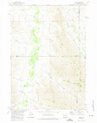
1972 Map of Lariat
USGS Topo · Published 1975About this map
The Powder River cuts a wide, meandering path through this high-plains landscape where the boundaries of Sheridan, Johnson, and Campbell counties converge. In the early 1970s, this region remained a stark network of drainage draws and rangeland, defined by its water sources and essential transport corridors. The small settlement of Lariat sits at the eastern edge of the quadrangle, anchored by a Corral and the Burlington Northern railroad line that parallels Wild Horse Creek.
Find a feature on this map
20 named features on this map. Tap any name to fly to it.
Don’t see what you’re looking for? This feature index may not catch every label — zoom into the map to look around manually.
Map Details
Editions of this 1972 Lariat Map
This is the sole edition of this map. No revisions or reprints were ever made.
Other maps of this area

1954 · Gillette
USGS Topo · 1:250,000

1955 · Sheridan
USGS Topo · 1:250,000

1955 · Gillette
USGS Topo · 1:250,000

1958 · Gillette
USGS Topo · 1:250,000

1958 · Sheridan
USGS Topo · 1:250,000

1962 · Gillette
USGS Topo · 1:250,000

1962 · Sheridan
USGS Topo · 1:250,000

1971 · Larey Draw
USGS Topo · 1:24,000

1971 · Arvada
USGS Topo · 1:24,000
1971 · Arvada NE
USGS Topo · 1:24,000