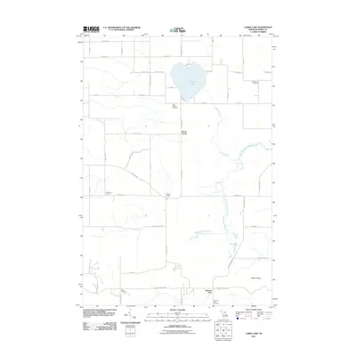
2011 Map of Larks Lake
USGS Topo · Published 2011About this map
Larks Lake sits at the heart of this Emmet County landscape, anchoring a rural network of farm-to-market roads and small settlements in northern Michigan. The area is defined by the winding course of the West Branch Maple River and Brush Creek, which flow through a mix of open land and woodlots. For local historians, the map identifies several distinct crossroads and community markers, including Marsh Corner, Maple Tree Corners, and the village of Pleasant View. These points of interest, combined with scattered family and community sites like Starr Cemetery and Saint Nichols Cemetery, reflect the early 21st-century character of this Michigan interior. To the south, the terrain rises toward Mount Pisage, while Camp Pellston provides a glimpse into the seasonal use of the region's natural resources and waterways like Four Lakes.
Find a feature on this map
51 named features on this map. Tap any name to fly to it.
Don’t see what you’re looking for? This feature index may not catch every label — zoom into the map to look around manually.
Map Details
Editions of this 2011 Larks Lake Map
This is the sole edition of this map. No revisions or reprints were ever made.
Other maps of this area

1955 · Cheboygan
USGS Topo · 1:250,000

1958 · Cheboygan
USGS Topo · 1:250,000

1958 · Cross Village
USGS Topo · 1:62,500

1958 · Pellston
USGS Topo · 1:62,500

1958 · Bayshore
USGS Topo · 1:62,500

1958 · Petoskey
USGS Topo · 1:62,500

1975 · Petoskey NW
USGS Topo · 1:24,000

1975 · Petoskey NE
USGS Topo · 1:24,000

1982 · Petoskey
USGS Topo · 1:100,000
1982 · Levering
USGS Topo · 1:25,000
Featured Places
- Pleasantview Township, MI
- Marsh Corner, MI
- Pleasantview, MI
- Cross Village Township, MI
- Friendship Township, MI