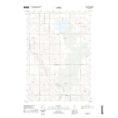
2019 Map of Larks Lake
USGS Topo · Published 2019About this map
Larks Lake and its surrounding wetlands define this portion of northern Emmet County, characterized by a complex network of glacial hydrology and recreational corridors. The landscape is marked by the Larks Lake Swamp and the headwaters of the West Branch Maple River, which meanders through the lowlands south toward Four Lakes. For family historians, the area is anchored by several long-established burial grounds, including Saint Nichols Cem and Greenwood Cem. The southern portion of the quadrangle includes the community of Pleasant View, situated near the base of Mt Pisage. This modern survey documents the contemporary intersection of local transportation and conservation, notably where the N Country National Scenic Trail and the Iron Belle Trail traverse the wooded hills and swamp margins, following the routes of rural corridors like Larks Lake Rd.
Find a feature on this map
50 named features on this map. Tap any name to fly to it.
Don’t see what you’re looking for? This feature index may not catch every label — zoom into the map to look around manually.
Map Details
Editions of this 2019 Larks Lake Map
This is the sole edition of this map. No revisions or reprints were ever made.
Other maps of this area

1955 · Cheboygan
USGS Topo · 1:250,000

1958 · Cheboygan
USGS Topo · 1:250,000

1958 · Cross Village
USGS Topo · 1:62,500

1958 · Pellston
USGS Topo · 1:62,500

1958 · Bayshore
USGS Topo · 1:62,500

1958 · Petoskey
USGS Topo · 1:62,500

1975 · Petoskey NW
USGS Topo · 1:24,000

1975 · Petoskey NE
USGS Topo · 1:24,000

1982 · Petoskey
USGS Topo · 1:100,000
1982 · Levering
USGS Topo · 1:25,000
Featured Places
- Pleasantview Township, MI
- Marsh Corner, MI
- Pleasantview, MI
- Cross Village Township, MI
- Friendship Township, MI