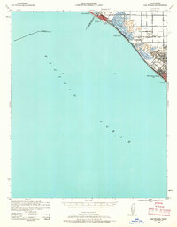
1941 Map of Las Bolsas
USGS Topo · Published 1963About this map
The coastal edge of Orange County at the start of the 1940s reveals a landscape defined by wetlands and recreational hunting grounds before the post-war suburban boom. Between Seal Beach and Huntington Beach, the shoreline is dotted with marshy inlets and exclusive sporting facilities like the Bolsa Chica Gun Club and Sunset Gun Club. The presence of the Pacific Electric railway running parallel to the coast highlights the importance of the "Red Car" system in connecting these seaside communities to the larger Los Angeles basin.
Find a feature on this map
24 named features on this map. Tap any name to fly to it.
Don’t see what you’re looking for? This feature index may not catch every label — zoom into the map to look around manually.
Map Details
Editions of this 1941 Las Bolsas Map
2 editions found
Other maps of this area

1896 · Santa Ana
USGS Topo · 1:62,500

1896 · Anaheim
USGS Topo · 1:62,500

1896 · Redondo
USGS Topo · 1:62,500

1896 · Las Bolsas
USGS Topo · 1:62,500

1896 · San Pedro
USGS Topo · 1:62,500

1896 · Downey
USGS Topo · 1:62,500

1898 · Anaheim
USGS Topo · 1:62,500

1899 · Downey
USGS Topo · 1:62,500

1901 · Southern California Sheet No. 1
USGS Topo · 1:250,000

1901 · Santa Ana
USGS Topo · 1:62,500