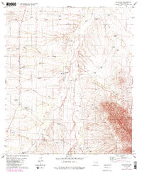
1979 Map of Las Guijas
USGS Topo · Published 1984About this map
The Las Guijas Mountains dominate the southeastern landscape of this Pima County survey, an area defined by the intermittent drainage of Altar Wash and Arivaca Wash. The map records a working cattle and mining landscape during the late 1970s and early 1980s, marked by scattered water sources like Martinez Well, Lindberg Tank, and Tiohierro Tank that supported local ranching operations such as Figueroa Ranch. Evidence of mineral exploration and extraction is visible throughout the slopes, notably at the Las Guijas Mine and various unnamed Prospects and Drill Holes. The transport network consists largely of unimproved roads and light-duty routes such as Shaffer, highlighting the rural character of the terrain between the Santa Margarita Wash and Arivaca Creek.
Find a feature on this map
37 named features on this map. Tap any name to fly to it.
Don’t see what you’re looking for? This feature index may not catch every label — zoom into the map to look around manually.
Map Details
Editions of this 1979 Las Guijas Map
2 editions found
Other maps of this area

1920 · Arivaca
USGS Topo · 1:125,000

1940 · Palo Alto Ranch
USGS Topo · 1:62,500

1941 · Presumido Peak
USGS Topo · 1:62,500

1941 · Baboquivari Peak
USGS Topo · 1:62,500

1941 · Arivaca
USGS Topo · 1:62,500

1943 · Fresnal
USGS Topo · 1:125,000

1943 · Arivaca
USGS Topo · 1:62,500

1943 · Palo Alto Ranch
USGS Topo · 1:62,500

1943 · Presumido Peak
USGS Topo · 1:62,500

1944 · Baboquivari Peak
USGS Topo · 1:62,500