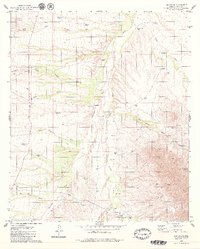
1979 Map of Las Guijas
USGS Topo · Published 1979About this map
The Las Guijas Mountains dominate this arid landscape, where desert water management is the primary marker of human presence. Dozens of named reservoirs and wells, such as Martinez Well, Tiohierro Tank, and Lindberg Tank, highlight the critical infrastructure required for ranching and mining in Pima County. The map documents the Las Guijas Mine and the nearby Las Guijas (Site), alongside family-named locales like Figueroa Ranch, Shaffer, and Secundino.
Find a feature on this map
40 named features on this map. Tap any name to fly to it.
Don’t see what you’re looking for? This feature index may not catch every label — zoom into the map to look around manually.
Map Details
Editions of this 1979 Las Guijas Map
2 editions found
Other maps of this area

1920 · Arivaca
USGS Topo · 1:125,000

1940 · Palo Alto Ranch
USGS Topo · 1:62,500

1941 · Presumido Peak
USGS Topo · 1:62,500

1941 · Baboquivari Peak
USGS Topo · 1:62,500

1941 · Arivaca
USGS Topo · 1:62,500

1943 · Fresnal
USGS Topo · 1:125,000

1943 · Arivaca
USGS Topo · 1:62,500

1943 · Palo Alto Ranch
USGS Topo · 1:62,500

1943 · Presumido Peak
USGS Topo · 1:62,500

1944 · Baboquivari Peak
USGS Topo · 1:62,500