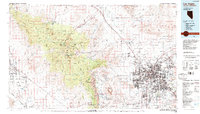
1986 Map of Las Vegas
USGS Topo · Published 1986About this map
Las Vegas and its surrounding desert valley appear in 1986 as a rapidly expanding urban center defined by its proximity to massive federal land holdings. The map illustrates the city's concentrated growth in the valley floor, bordered by the Spring Mountains to the west and the sprawling Nellis Air Force Range and Desert National Wildlife Range to the north. Industrial and transport lifelines are visible through the Union Pacific rail line and the infrastructure of McCarran International Airport.
Find a feature on this map
40 named features on this map. Tap any name to fly to it.
Don’t see what you’re looking for? This feature index may not catch every label — zoom into the map to look around manually.
Map Details
Editions of this 1986 Las Vegas Map
4 editions found
Other maps of this area

1886 · Camp Mohave
USGS Topo · 1:250,000

1886 · Saint Thomas
USGS Topo · 1:250,000

1892 · Camp Mohave
USGS Topo · 1:250,000

1893 · Saint Thomas
USGS Topo · 1:250,000

1907 · Las Vegas
USGS Topo · 1:250,000

1908 · Furnace Creek
USGS Topo · 1:250,000

1908 · Las Vegas
USGS Topo · 1:250,000

1910 · Furnace Creek
USGS Topo · 1:250,000

1910 · Ivanpah
USGS Topo · 1:250,000

1912 · Ivanpah
USGS Topo · 1:250,000