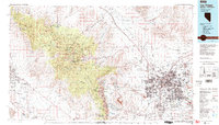
1986 Map of Las Vegas
USGS Topo · Published 1986About this map
The growing metropolitan footprint of Las Vegas and North Las Vegas dominates the eastern half of this mid-1980s landscape, illustrating the rapid expansion of residential street grids and industrial zones toward Henderson. Beyond the valley floor, the map details the high-altitude terrain of the Spring Mountains, where Charleston Peak and Wheeler Peak tower over the Toiyabe National Forest. This era shows the developed infrastructure of Nellis Air Force Base and the North Las Vegas Air Terminal supporting the region's aerial needs.
Find a feature on this map
43 named features on this map. Tap any name to fly to it.
Don’t see what you’re looking for? This feature index may not catch every label — zoom into the map to look around manually.
Map Details
Editions of this 1986 Las Vegas Map
4 editions found
Other maps of this area

1886 · Camp Mohave
USGS Topo · 1:250,000

1886 · Saint Thomas
USGS Topo · 1:250,000

1892 · Camp Mohave
USGS Topo · 1:250,000

1893 · Saint Thomas
USGS Topo · 1:250,000

1907 · Las Vegas
USGS Topo · 1:250,000

1908 · Furnace Creek
USGS Topo · 1:250,000

1908 · Las Vegas
USGS Topo · 1:250,000

1910 · Furnace Creek
USGS Topo · 1:250,000

1910 · Ivanpah
USGS Topo · 1:250,000

1912 · Ivanpah
USGS Topo · 1:250,000