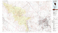
1986 Map of Las Vegas
USGS Topo · Published 1986About this map
Las Vegas and its surrounding desert valley undergo significant expansion during the mid-1980s, anchored by the Union Pacific railroad corridor and the growing infrastructure of McCarran International Airport. While the urban core of North Las Vegas and Henderson dominates the eastern landscape, the western reaches are defined by the high elevations of the Spring Mountains and the protected lands of the Toiyabe National Forest. The map captures the specialized geography of the region, from the academic campus of the University of Nevada to the sprawling military installations at Nellis Air Force Base and the Nellis Air Force Range. Smaller outlying communities such as Blue Diamond, Arden, and Mountain Springs provide a look at the transition from the densely populated Las Vegas Valley to the more isolated Pahrump Valley along the California border.
Find a feature on this map
59 named features on this map. Tap any name to fly to it.
Don’t see what you’re looking for? This feature index may not catch every label — zoom into the map to look around manually.
Map Details
Editions of this 1986 Las Vegas Map
4 editions found
Other maps of this area

1886 · Camp Mohave
USGS Topo · 1:250,000

1886 · Saint Thomas
USGS Topo · 1:250,000

1892 · Camp Mohave
USGS Topo · 1:250,000

1893 · Saint Thomas
USGS Topo · 1:250,000

1907 · Las Vegas
USGS Topo · 1:250,000

1908 · Furnace Creek
USGS Topo · 1:250,000

1908 · Las Vegas
USGS Topo · 1:250,000

1910 · Furnace Creek
USGS Topo · 1:250,000

1910 · Ivanpah
USGS Topo · 1:250,000

1912 · Ivanpah
USGS Topo · 1:250,000