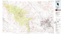
1986 Map of Las Vegas
USGS Topo · Published 1986About this map
Las Vegas and its surrounding valleys are captured here during a decade of transformative growth, showing the urban footprint expanding toward the Spring Mountains. The desert landscape is defined by its dramatic elevation changes, from the heights of Charleston Peak within the Toiyabe National Forest to the floor of the Pahrump Valley. While the central city anchors the map, the surrounding infrastructure of the mid-1980s is visible in detail, including the Nellis Air Force Base complex and the Union Pacific rail lines serving the industrial corridor through Arden.
Find a feature on this map
50 named features on this map. Tap any name to fly to it.
Don’t see what you’re looking for? This feature index may not catch every label — zoom into the map to look around manually.
Map Details
Editions of this 1986 Las Vegas Map
4 editions found
Other maps of this area

1886 · Camp Mohave
USGS Topo · 1:250,000

1886 · Saint Thomas
USGS Topo · 1:250,000

1892 · Camp Mohave
USGS Topo · 1:250,000

1893 · Saint Thomas
USGS Topo · 1:250,000

1907 · Las Vegas
USGS Topo · 1:250,000

1908 · Furnace Creek
USGS Topo · 1:250,000

1908 · Las Vegas
USGS Topo · 1:250,000

1910 · Furnace Creek
USGS Topo · 1:250,000

1910 · Ivanpah
USGS Topo · 1:250,000

1912 · Ivanpah
USGS Topo · 1:250,000