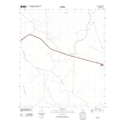
2010 Map of Lasca
USGS Topo · Published 2010About this map
Etholen and Lasca anchor this desert landscape in Hudspeth County, where the infrastructure of transportation and ranching intersects with the foothills of the Quitman Mountains. The 2010 survey highlights a critical corridor of movement along the Access Rd, paralleling a major rail line that connects these high-desert outposts. The reliance on water management in this arid environment is evident through a series of named catchments, including Etholen Tank, Granger Tank, and Deer Tank, which support the surrounding range. Named ranching landmarks like Love Ranch sit amongst a network of local tracks such as Cowser Rd and The Boulevard. Geological features like Skunk Canyon and the seasonal Lasca Branch define the drainage patterns that flow toward the Red Light Draw to the south. This era of the map reflects a landscape of vast distances where small settlements and livestock tanks serve as the primary markers of human presence.
Find a feature on this map
21 named features on this map. Tap any name to fly to it.
Don’t see what you’re looking for? This feature index may not catch every label — zoom into the map to look around manually.
Map Details
Editions of this 2010 Lasca Map
This is the sole edition of this map. No revisions or reprints were ever made.
Other maps of this area

1894 · Fort Hancock
USGS Topo · 1:125,000

1895 · Sierra Blanca
USGS Topo · 1:125,000

1943 · Fort Quitman
USGS Topo · 1:62,500

1943 · Finlay Mountains
USGS Topo · 1:62,500

1948 · Triple Hill
USGS Topo · 1:62,500

1954 · Van Horn
USGS Topo · 1:250,000

1958 · Van Horn
USGS Topo · 1:250,000

1964 · Devil Ridge
USGS Topo · 1:24,000

1964 · Lasca
USGS Topo · 1:24,000

1964 · Sierra Blanca SW
USGS Topo · 1:24,000